General News
7 January, 2023
Creek of many names
SUMMER READINGBy KEN ARNOLDTHE watershed for the Bul a Bul, also refered to as the Sandy, Bullabul or Kingarra creek depending on which map or newspaper one may read, commences in the hills just east of Moliagul, just off the Wimmera Highway. As...
SUMMER READING
By KEN ARNOLD
THE watershed for the Bul a Bul, also refered to as the Sandy, Bullabul or Kingarra creek depending on which map or newspaper one may read, commences in the hills just east of Moliagul, just off the Wimmera Highway.
As this area is rather flat, the flood plain creek roughly follows the highway for some distance, it passing over the Dunolly-Orville road before being joined by two other smaller streams before it passes under the Wimmera Highway near Rooney’s Lane on under the Castleman’s bridge, Dunolly-Rheola road on under Hangman’s Lane, on over Keogh’s lane where it merges with the water from the Dead Log Creek.
The nearby Dead Log creek flows from around Rooney’s Lane then under the Wimmera Highway, then the Dunolly-Rheola road before it is joined by the Magpie Creek before passing over Scurry road, it merging with two flood plains before flowing onwards into swampy land, in Hangman’s Lane, on into the Bul a Bul Creek.
It was around this area that one of the Llanelly reservoirs was constructed, however today there is no evidence of the wall.
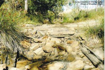
The Bul a Bul creek is joined by the water from Sandy creek, which rises in Tarnagulla, at the Irishtown Bridge, on the Rheola-Llanelly road, at Murphys Creek.
The creek then flows through a snarl of old logs and trees before passing over a stone and cement culvert on to where it is met by a small stream that flows from the west over Simpson Creek Lane.
This reserve, now known as the Bulabul Creek streamside reserve is a peaceful area to visit. It can be found by turning off the Rheola-Llanelly road into Riordan Lane, before turning left into an unnamed lane or you can approach the reserve from Simpson Creek Lane.
It can be found by turning right where the small creek crosses the road. This track can be rough at times, owing to damage by flood water and tyre tracks.
When full this old reservoir has maybe three metres of water, it being fairly clear of snags, it once being the second reservoir for Llanelly. It has been a favourite camping spot for the gypsie wagons.
The Bul a Bul Creek then flows down over Mickeys Lane on past Castle Eaton, over Wilson Lane, the old bridge having been burnt out in the 1965 bushfire, down over a private crossing onto where it meets the Kangderaar Creek. The creek next runs a short distance down over an unnamed lane on over Mathesons Road on under the Dunolly-Inglewood railway line, then under Black Bridge, also burnt out in 1965, where the creek almost comes out to the Bridgewater-Dunolly road.
It was in this area where the flood water of the creek and those of the nearby Loddon River have merged on many occasions hence the main road became flooded, sometime to a depth of two feet or more.
The creek wends it way northwards passing by the old Bul a Bul railway station site on under Sloans Road onwards under the Calder highway and the Bendigo-Inglewood railway line.
The Bul a Bul Creek then flows down under the Bridgewater-Serpentine road onwards until it reaches the Loddon River.
Just a short distance downstream from the junction of the Kangderaar and Bul a Bul creeks David Arnold, who held the pre emptive rights to three small paddocks, now marked by two large fig trees which are over 100 years old, and his sons William John and David Russell built a simple three-log with decking bridge nearby in 1859, this being a toll bridge with a refreshment tent on the other side.
It is recorded that a wagon loaded with wool was the first traffic to pass over the bridge. This crossing became known as Arnold’s Bridge, this being shortened to Arnold around 1920.
The Tarnagulla Courier newspaper gives the address for the application for a beer licence as Kangaroo bridge, Tarnagulla road in February 1865.
In the meantime the bridge had been washed away. Although it was rebuilt the Shire of Bet Bet called tenders for a more permanent bridge on April 9, 1873. Thus a 120 foot long by twenty foot high bridge was built just upstream by Messrs. Milne & Gartley, it being opened on December 2.
The floods of March 1878 washed away the approaches to the bridge thus tenders for repairs were soon called.
Tenders were called to redeck the Arnold bridge on April 11, 1913. The Arnold bridge served the passing trade until around 1948 when a new bridge was built. At that time the Arnold-Inglewood road ran down the north side of the old closed Junction hotel. As the bridge was burnt out in January 1965 bushfire, the road was realigned in readiness for two new concrete bridges to be built.